Project region Myanmar
Myanmar is home to 51,486,253 people in 15 states and regions (The Republic of the Union of Myanmar 2015). With an average population density of 76.1 people per km2. there are large urban-rural differences. Nationwide, about 30% of the population lives in urban areas. In the Yangon region, the percentage of urban population is by far the highest at 70%, while in rural areas (e.g. the Ayeyarwady Delta, Magway and Sagaing Regions, Rakhine State) it is only 14-17% (The Republic of the Union of Myanmar 2015).
In 2018 Myanmar was ranked on 148th out of 189 in the Human Development Index (UNDP 2018a), which is due to the relatively low life expectancy at birth (66.8 years) and the low number of actual school years of 4.9 years on average (UNDP 2018b). Ten years of schooling are statuory in the education system system (The Republic of the Union of Myanmar 2015). In a global comparison, Myanmar performs well in terms of equality between men and women (GDI: global average = 0.941, Myanmar = 0.959; GII: global average = 0.441; Myanmar = 0.456) (UNDP 2018a).
Myanmar holds a key political and economic position in Southeast Asia. The country between China, Laos, Thailand, Bangladesh and India forms the transition from Southeast Asia to East and South Asia. Myanmar holds intensive trade relations with Thailand, China and India as well as Malaysia, Indonesia and Singapore (Kraas 2019).
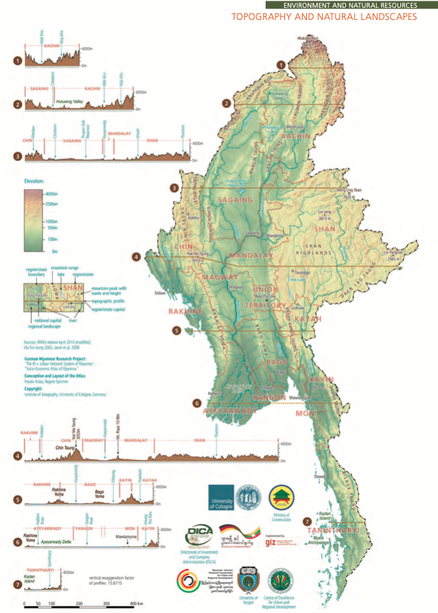
Myanmar covers an area of 676,577.2 km2, which can be divided into seven natural areas (Kraas et al. 2017; Kraas 2019) (see figure on the right):
-
Rakhine coast at the foot of Rakhine Mountains (high precipitation area)
-
North-South directed Rakhine Mountains (Western area)
-
Himalaya foothills in the Northern areas (high mountain rain forest)
-
Shan highlands (Eastern areas)
-
Dry zone located in the lee side of the Rakhine Mountains
-
Warm and humid as well as fertile Ayeyarwady Delta
-
Thanintharyi coast in the border zone to Thailand (warm and high precipitation area)
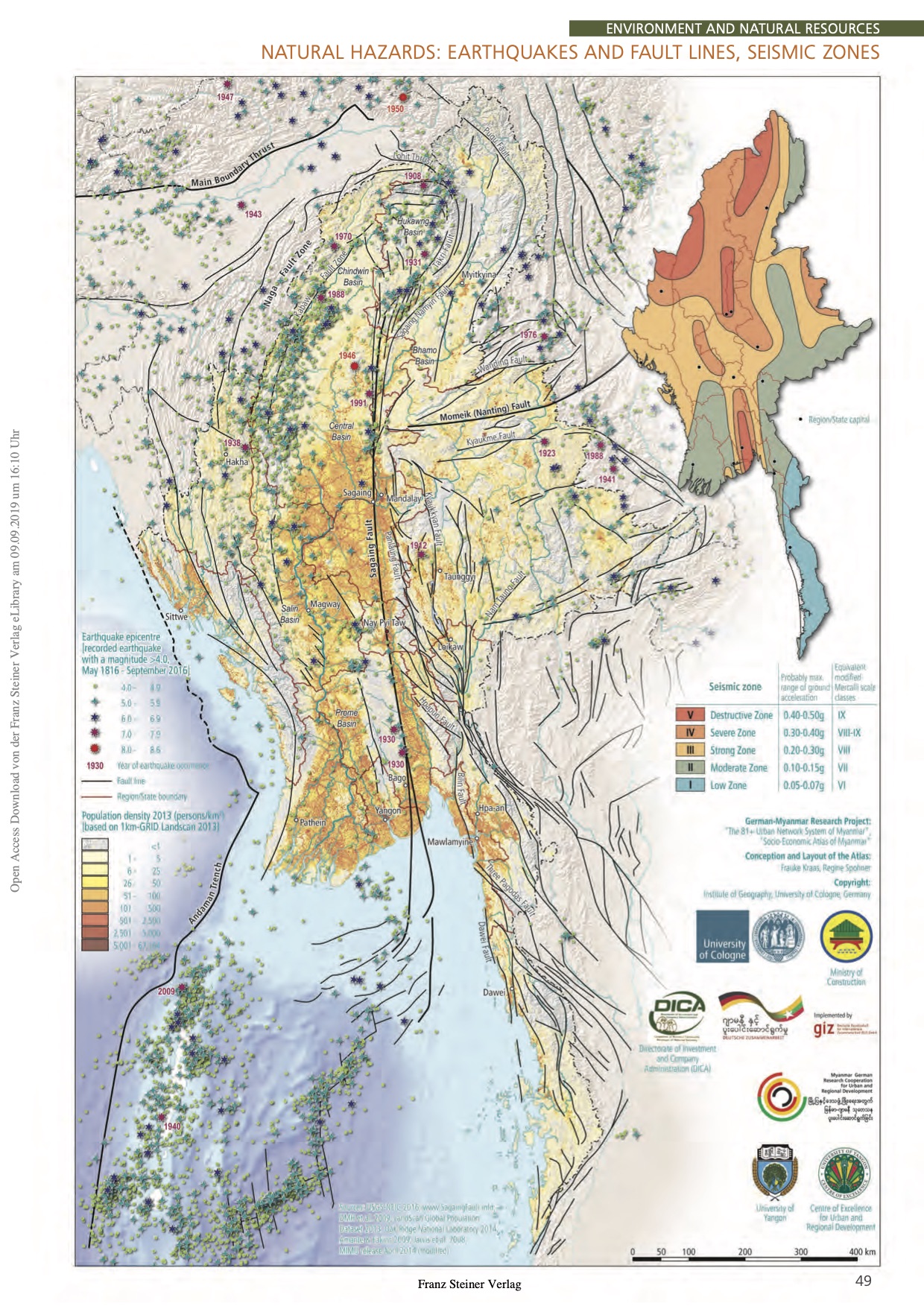
Myanmar is situated in tectonically active zone. The location of the tectonic plates, the Burma and Sunda plates off the coast of Myanmar, may cause seaquakes in this region, which may threaten the coastal regions of Myanmar as tsunamis. A seaquake caused by a collision between the Sunda and Burma plates caused the devastating tsunami in December 2004 (Hayes et al. 2013).
Due to the collision of the Indian and Eurasian plates in the interior of the country, Myanmar is situated in a seismically active zone characterized by several fault lines (Kraas et al. 2017). The most striking is the Sagaing fault line, which stretches about 1300 km from Kachin State in the north across the eastern Ayeyarwady delta to the shelf off Dawei. Here are active earthquake zones including volcanoes and hot springs (see figure right).
Depending on the region, there are heavy monsoon rains between June and September. Tropical cyclones occur in the pre-monsoon phase (April to June) and the post-monsoon (October to November), when air masses above the heated land mass meet the cold air masses of the oceans (Kraas 2019).
In June 2008, tropical cyclone Nargis hit coastal regions and the Ayeyarwady Delta, claiming 84,537 lives and 53,836 people were missing (Driel and Nauta 2015, 2; Kraas et al. 2017). In 2015 the cyclon Komen inundated 525 330 ha of arable land and 122 people lost their lives, 1 624 000 lost their livelihoods (FAO et al. 2012, 6) (see left Figure).
Therefore, the Action Plan on Disaster Risk Reduction was by the National Disaster Management Committee. This document sets general aims for future DRM in Myanmar.
In the future, improved infrastructure and disaster preparedness should reduce disaster risks. To this end, the Action Plan on Disaster Risk Reduction was established by the National Disaster Management Committee in 2017, which defines key targets for future disaster prevention (National Disaster Management Committee 2017).

Bibliography:
Driel, Wim van, and Tjitte Nauta. 2015. ‘Vulnerability and Resilience Assessment of the Ayeyarwady Delta, Myanmar.’ Full Assessment Report 10. Delta Alliance Report. Delft-Wageningen: Bay of Bengal Large Marine Ecosystem (BOBLME) Project, Global Water Partnership (GWP) and Delta Alliance.
FAO, MOAI, MLFRD, and WFP. 2012. ‘Agriculture and Livelihood Flood Impact Assessment in Myanmar’. Food and Agriculture Organization of the UN. http://www.fao.org/emergencies/resources/documents/resources-detail/en/c/338553/.
Hayes, Gavin P., Melissa Bernardino, Fransiska Dannemann, Gregory Smoczyk, Richard W. Briggs, Harley M. Benz, Kevin P. Furlong, and Antonio Villaseñor. 2013. ‘Seismicity of the Earth 1900-2012 Sumatra and Vicinity’. USGS Numbered Series 2010-1083–L. Open-File Report. Reston, VA: U.S. Geological Survey. http://pubs.er.usgs.gov/publication/ofr20101083L.
Kraas, Frauke. 2019. Myanmar in Process of Transformation. Diercke Spezial. Aktuelle Ausgabe Für Die Sekundarstufe II. Braunschweig: Westermann. https://www.westermann.de/artikel/978-3-14-151126-0/Diercke-Spezial-Aktuelle-Ausgabe-fuer-die-Sekundarstufe-II-Myanmar-in-Process-of-Transformation.
Kraas, Frauke, Regine Spohner, Aye Aye Myint, Aung Kyaw, Hlaing Maw Oo, Htun Ko, Khin Khin Han, et al. 2017. Socio-Economic Atlas of Myanmar. Franz Steiner Verlag. https://elibrary.steiner-verlag.de/book/99.105010/9783515116251.
National Disaster Management Committee. 2017. Myanmar Action Plan Om Disaster Risk Reduction, 2017: Fostering Resilient Development through Intergrated Action Plan.
The Republic of the Union of Myanmar. 2015. ‘The 2014 Myanmar Population and Housing Census. The Union Report’. Census Report Volume 2. Department of Population Monostry of Immigration and Population. http://myanmar.unfpa.org/census.
UNDP. 2018a. ‘Human Development Index and Indicators. 2018 Statistical Update’. New York: United Nations Development Programme. http://hdr.undp.org/en/countries/profiles/MMR.
UNDP. 2018b. ‘Myanmar Country Profile’. 2018 Statistial Update. Human Development Indices and Indicators. New York: United Nations Development Programme. http://hdr.undp.org/en/countries/profiles/MMR.
UNOCHA. 2017. ‘Myanmar: Recent Natural Disaster Overview (as of 28 June 2017)’. Thematic Map. https://reliefweb.int/map/myanmar/myanmar-recent-natural-disasters-overview-28-june-2017.